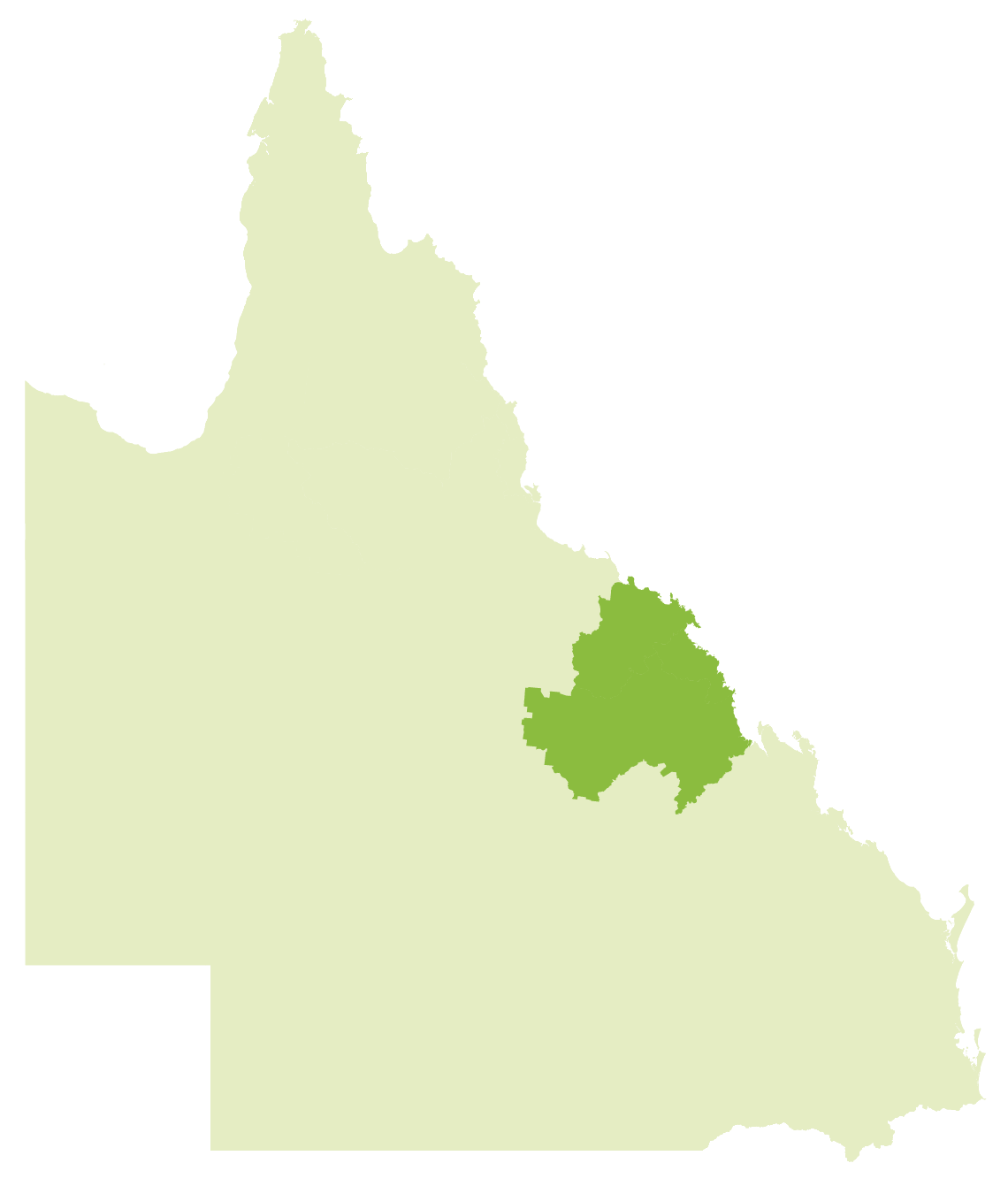
The Greater Whitsunday region is one that celebrates its unique diversity.
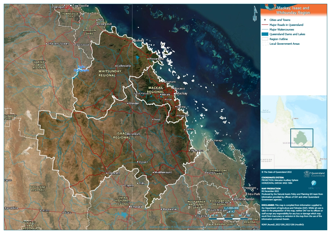
The Greater Whitsunday region covers 90,354 square km and comprises three local government areas (LGAs) managed by Mackay Regional Council, Isaac Regional Council and Whitsunday Regional Council. It is bounded by St Lawrence in the south, Gumlu in the north, out to Clermont in the west and the Great Barrier Reef Whitsunday’s group of 74 islands to the east. The region is home to around 190,000 people spread across a number of key regional centres, islands and rural communities. Considered one of the most resource-rich areas in Australia, the Greater Whitsunday region has become an economic powerhouse across key industry sectors such as mining, manufacturing, agriculture, health care and social assistance, tourism, and construction. It is recognised as a major part of Queensland’s economy as well as a world-renowned tourist destination.
The Greater Whitsunday region has a long relationship with drought. The region is the traditional country of several First Nations language groups – particularly the Juru, Gia, Ngaro, Yuwibara, Koinmerburra, Barada and Wiri and Widi People. They and their ancestors have had a long connection to the land and water, that is anchored deeply in their cultural, spiritual and historical identity, and, as such, also had experience and deep knowledge of drought.
Past impacts of drought in this region
Past impacts | People, culture & community
EXTRACTS FROM THE FULL RDRP PLAN
Figure 20: Population change projection for three LGAs of Greater Whitsunday Region.
There is evidence that drought is recognised as a “normal part of life” in the western parts of the Greater Whitsunday region, and to a certain extent the experience of drought is less “shocking” than reported other regions. Changes to climate or rainfall also don’t have a significant impact on population growth for the region. However, there is evidence drought has had a noticeable impact on a number of factors and therefore clear action should be taken to address these factors – addressing the negative and enhancing the positive – in order to strengthen community drought resilience for the future. During engagement, many participants highlighted the impact of drought on health and wellbeing, particularly mental health.
“It’s frustrating talking to someone in Brisbane who has never set foot on a farm or property, telling you what they can or can’t do for you based on what they see on a computer screen. We want local people on the ground who understand more about the land, and what we are going through.”
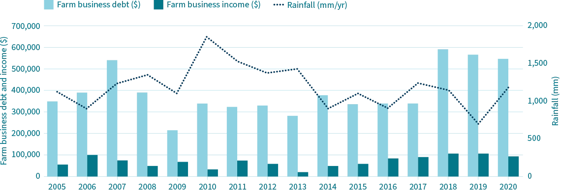
Past impacts | Economy
EXTRACTS FROM THE FULL RDRP PLAN
Figure 28: Farm business debt and income for the Curtis to Morton ABARES region.
The economy of the region is dominated by the mining sector, with contributions from construction, manufacturing, agriculture and several service and administrative sectors. For both sugar production and beef cattle numbers, there is little correlation with rainfall. The Mackay region has a stable climate and a relatively low risk to drought, and therefore with diversified crops could provide a high value crop opportunity driven by high demand and low supply when other parts of Queensland and Australia are in drought.
“It feels like the government makes it hard on purpose to avoid having to pay out.”
Past impacts | Landscape and natural environment
EXTRACTS FROM THE FULL RDRP PLAN
Whitehaven Beach, Whitsundays, Queensland.
Traditional Owners of the regions managed the country by living with the landscape, including in their understanding and management of the impacts of drought. In recent times it has been recognised that stemming the loss of traditional land management practice knowledge and sharing this knowledge in a culturally appropriate manner is key to building more drought resilient landscapes and communities of this region.
Currently however, a key result of drought for this region is the excess fine sediment delivery which is a major contributor to the declining health of the Great Barrier Reef. The region also faces invasive weed infestation, particularly after drought. Many terrestial and aquatic flora and fauna are affected by drought due to prolonged periods of hot days, or reduced water quality.
Past impacts | Infrastructure and built environment
EXTRACTS FROM THE FULL RDRP PLAN
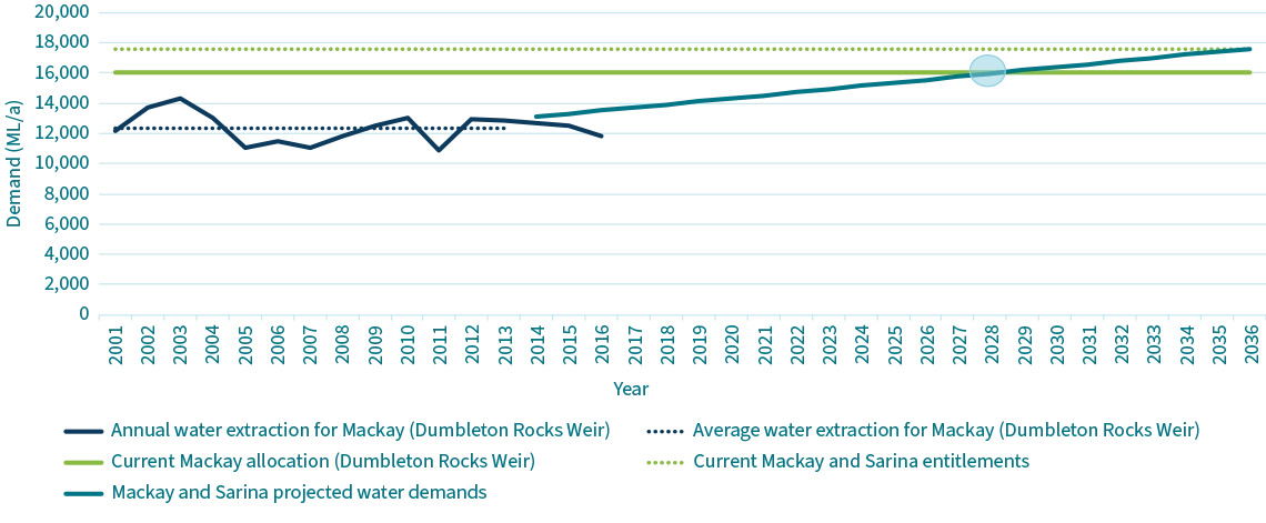
Figure 36: Mackay regional water supply security assessment.
Water security is a priority for the Greater Whitsundays region, with groundwater as the main source of water supply, and large volumes of supplemented water supplied through the region via other supply schemes. Allocations from the supplemented water supply schemes are subject to low levels of utilisation, making them more risk-prone.
Regional transport is also a priority for the region, focussing on: a transport system that supports economic development; a more resilient transport network; a transport system that is safe for customers; and prioritising liveable and connected communities.
Likely future impacts of drought in this region
Theresa Creek Dam near Clermont.
The Queensland Department of the Environment, Tourism, Science and Innovation has modelled future climatic conditions for the Greater Whitsundays region and predicted the following future scenarios:
higher temperature
hotter and more frequent hot days
more intense downpours
less frequent but more intense tropical cyclones
rising sea levels
more frequent sea-level extremes
warmer and more acidic seas.
Under both a low and high emissions scenario, the mean temperature is predicted to rise across the region with the Mackay having the lowest increase and Isaac the largest increase in temperature. In a low emissions scenario, Isaac is predicted to experience the largest decline in annual rainfall while all the shires are predicted to have lower rainfall in all scenarios. The increase in temperature is also likely to lead to higher fire risk.
Regional strategy
Regional strategy | People, culture & community
EXTRACTS FROM THE FULL RDRP PLAN
Planning and monitoring
Projected outcome: Communities use a resilience framework to monitor the level of resilience readiness of organisations, groups and individuals. Results are used to design systemic processes in each community to maintain – and where needed – develop resilience levels.
Respond to drought events
Projected outcome: Greater Whitsundays communities with ready access to the information they need to respond to drought situations.
Build future resilience
Projected outcome: Enable people and communities to gain the skills to increase resilience to drought and other adverse events.
Regional strategy | Economy
EXTRACTS FROM THE FULL RDRP PLAN
Planning and monitoring
Projected outcome: The regional economy is better prepared for dry times and drought through planning to provide jobs and retain a regional workforce which will sustain communities.
Respond to drought events
Projected outcome: Increased capacity to provide services, regional coordination, and support diversification and innovation to maintain the regional economy.
Build future resilience
Projected outcome: Support activities known to promote future resilience.
Regional strategy | Landscape and natural environment
EXTRACTS FROM THE FULL RDRP PLAN
Planning and monitoring
Projected outcome: Land managers are prepared and able to assess and understand what is required for resilience of landscapes and the natural environment.
Respond to drought events
Projected outcome: Enable land managers and communities to access and use information for making decisions.
Build future resilience
Projected outcome: Landscapes and land managers are better prepared for dry times and have the skills to manage in dry times.
Regional strategy | Infrastructure and built environment
EXTRACTS FROM THE FULL RDRP PLAN
Planning and monitoring
Projected outcome: A regional drought surveillance program in place monitoring and analysing key indicators of current and emerging environmental (meteorological and landscape), social, and economic conditions – which are markers of drought.
Respond to drought events
Projected outcome: Landholders and communities have capacity to respond to drought events through accessing grants and being aware of drought vulnerability indicators for the region.
Build future resilience
Projected outcome: Essential infrastructure is in place and maintained so communities and industries can access in dry times and drought.
View the Greater Whitsunday Regional Drought Resilience Plan